I have done a lot of online research regarding this topic and I am increasingly frustrated by the data that has been collected recently using a DA2/CAT1 with FieldMaps and beginning to second guess everything. As you read this, my accuracy requirements are generally less that 4-6", but obviously the tighter the better. Having read this post amongst many articles/forums and posts:
https://geospatial.trimble.com/en/resources/blog/best-practice-for-using-trimble-gnss-receivers-with-esri-arcgis-field-maps
- Set up a project in FieldMaps using the above resource with Trimble Mobile Manager set to Auto, used a DA2 transformation as instructed from NAD83/WGS84.
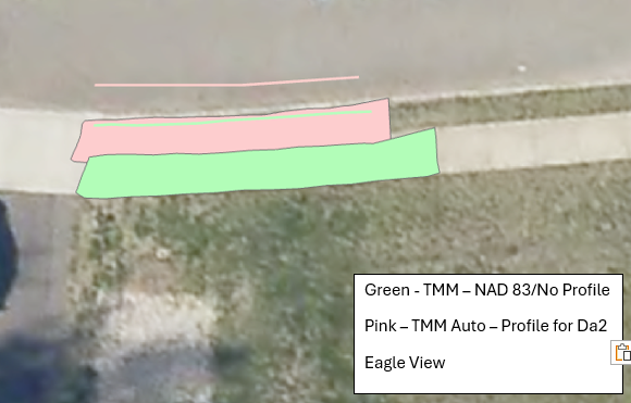
- This image below was overlaid using Eagle View's aerial imagery which they claim to have 1cm with ground control for their aerials. You can see a shift which started to make me wonder what was going on and dug deeper.

- Background - Cross checked Eagle View with other reputable imagery services locally and they line up perfectly with one another which gave me some confidence.
- Background - I have used the local imagery service has been used for years with RTK via NTRIP and any data collected with that method lines up to this service pretty darn close including data collected using Access/R12 with NTRIP. This gave me some confidence that Eagle View is okay to use for visual checks.
- Background - All data is published using a NAD83 2011 local State Plane coordinate system.
- Test 1: Making a copy of the data, I manually shifted these features over to where the look in "reality". I forced the datum NAD1983 out of TMM vs. Auto. I removed the profile and recollected the same features. The shifted line and the newly collected feature lined up within a tolerance that is acceptable. For some reference this is in California SP Zone V.
- Test 2: Setup a FieldMaps with a basemap set to NAD1983 with data also in SP83-NJ. TMM is set to Auto and no Datum transformation profile used. FieldMaps pops up a warning about a mismatch, but the data collected is where I would expect it to be within the expected tolerance.
- Test 3: Repeated the recommended setup in the Trimble Article for FieldMaps and collected data in front my house being able to utilize the local imagery service. The results are below with pink line/polygon collecting data with TMM set to Auto and a DA2 transformation. The green is recollecting the same features (curb and sidewalk) using the datum forced to NAD83 in TMM and no profile in FieldMaps, just default. The results look better in my opinion. - SP 83 Long Island for reference.
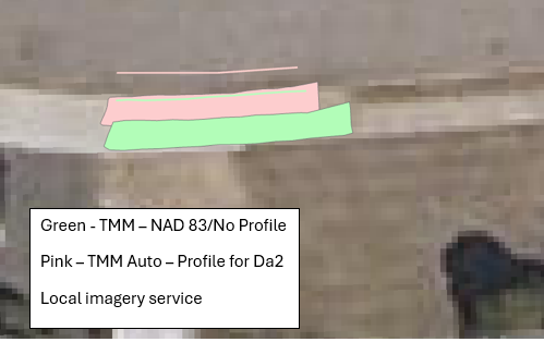
- Test 4: Repeated the same test as my home test at a local project. The shift was happening there as well. Had the same results... side note I was also streaming the local imagery service and the DA2 was lining up perfectly with it when I used no profile and forced Nad1983 outputs.
- Test 5: Trimble Connect/TerraFlex WMS is down, but waiting on the results of recollecting a few features in the Trimble native platform to compare with the test data. TBD
I guess my questions become:
- Why am I seeing a shift when using a profile as instructed?
- I read many an articles that states to publish your data in WGS84 like the default Esri basemaps and reproject it later. I don't love that idea for workflow and if I choose to do that, would the shapes/areas or linework be different after reprojecting?
- I haven't seen this issue having utilized a similar workflows with DA2/Catalyst, the TDC650, R2/580 and FieldMaps previously.
Any help from Mark, Matt or Gareth would be appreciated!
Thanks in advance.
------------------------------
Kara O'Neill
------------------------------