Mapping and GIS Solutions Community

 View Only
Expand all | Collapse all

UAV Ground Control App, support for different datum

  • 1.  UAV Ground Control App, support for different datum

    Posted 04-25-2020 12:30

    I just started working with the Trimble Catalyst using the UAV Ground Control app for creating check points for our drone maps.  We are currently using the Phantom 4 RTK with base station, and processing in Pix4D and Virtual Surveyor.

    When using the UAV Ground Control app, the points are recorded in ITRF2014 with the GRS80 model.  However, there appears to be no support for NAD83CSRS with CGVD2013.


    Our current workflow is to capture the control points and drone survey data in WGS84 and HAE, process the images, ground control, and check points in Pix4d, and set the Height Above Ellipsoid on output before bringing it into Virtual Surveyor to convert to NAD83CSRS.  This workflow will still provide horizontal error as the geoid offset varies and we can only set one value.


    Just looking for ideas, or if anyone has had similar issues and how you've managed to work through it?

    Thanks!


  • 2.  Re: UAV Ground Control App, support for different datum

    Posted 06-04-2020 14:19

    The latest version of UAV Ground Control and Trimble Mobile Manager (released 4th May 2020), now allow you to specify the requested output reference frame and to select a local Geoid from a list of pre-defined Geoids that are supported out of the box. If your required Geoid is not in the list of pre-supported models, you can custom load any GGF file to the Android device. Instructions for how to use this workflow are described here in the Trimble Mobile Manager help portal:


    Configure GNSS output 


    Once configured, UAV Ground Control will display and output MSL heights in your local vertical reference frame.


  • 3.  Re: UAV Ground Control App, support for different datum

    Posted 06-09-2020 04:54

    I'm having a problem that may be similar. In UAV Ground control the GEOID I need is not there, I need to purchase it and it's expensive. I am using catalyst and UAV Ground control for the same purpose to collect GCPs and processing in PIX4d. UAV Ground control is perfect for what we are doing, I am sure there are many others creating maps using photogrammetry that can benefit from a clear answer on this.


    PIX4d says the

    "Important: The output coordinate system does not need to be the same as the images' coordinate system or as the GCPs' coordinate system. It is recommended, though, that the output coordinate system is the same as the GCPs' coordinate system."


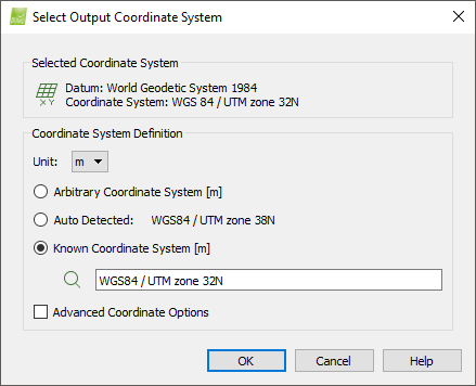
    If we can set the output in PIX4D to match the coordinate system in UAV Ground control, will that work?


    The format we get from UAV Ground control is this:


    The format PIX4d wants is this, I had to convert these to UTM to get PIX4D to place the points in my project.

    GCP001,53.85081039,10.67252061,44.937
    GCP002,53.84997769,10.67113496,45.704
    GCP002,53.84997769,10.67113505,45.707
    GCP004,53.84926137,10.67362433,62.31


    So it seems:

    We need an output in a different format according to PIX4D


    As PIX4d support said. "Pix4Dmapper will import the GCPs (they can be measured in geographic or projected coordinate systems) and then fit them to your image dataset. The good news is that the user can select any output coordinate system they want (the GCP coordinate system can be different), so the conversion of the GCPs to UTM might be redundant. I would keep the GCP coordinate system untouched, as you might lose some accuracy during the conversion operation"


    When it says Auto in Mobile manager, what coordinate system is that? If I know what it is I can start by matching the coordinate system to my project system.


  • 4.  Re: UAV Ground Control App, support for different datum
    Best Answer

    Posted 06-16-2020 08:09

    Hi Patrick


    The Auto (Trimble Correction Hub) GNSS Correction source represents the unique bundled correction service Catalyst uses (SBAS,RTX, VRSNow) - for more information take a look here Frequently Asked Questions |

    Different correction sources can be based on different datums - this Auto setting automatically applies the correct datum for the correction source you are using to eliminate errors.

    If you are using a CUSTOM LOCAL NTRIP source for example this would expose additional options to choose the source reference frame and Epoch which we do not need to worry about here


    The Trimble Mobile Manager help GNSS Configuration screen - provides more detail on this


    For your Application


    The Ground Control app will only output in WGS84 Lat/Lon (+ your height based on the defined geoid) 

    My advice here would be to configure the GNSS Output as I have done in the screengrab below to WGS84 with EGM96 (Global)

    You should easily be able to convert this with your software to the required UTM using their tools and guidance (sorry I can't help with Pix4DMapper)


    With regards to your Geoid - If you do decide to purchase it you can load this for use with the UAV GCP app by following the guide here: How to 'side-load' custom Geoid's for use in Trimble Mobile Manager 


  • 5.  Re: UAV Ground Control App, support for different datum

    Posted 09-13-2020 14:17

    Does anyone have a defined workflow for processing UAV Grund Control through Pix4D?

    Once thing i'm not sure on, the different height values output in the export file:

    • Height
    • Height at Ground
    • MSL height
    • MSLHeight at Ground


    I'm assuming we should be using one of the 'height at ground' values, as that has the length of the pole subtracted.

    Is Height at Ground the HAE?

    MSLHeight at Ground is from the selected Geoid (EGM96)?


    I guess we should be using MSLHeight at Ground and ensure it is selected in Pix4D as vertical coordinate system?


    Pix4d GCP Coordinate System Dialog