Trimble Business Center

 View Only

 TBC 5.60: Issues with Baseline Processing

Dustin Sunderman's profile image
Dustin Sunderman posted 02-28-2022 13:22
We are having an issue when processing static observations. We are in California and use Sopac to process live coordinates. 

When I create the file I pull the Lat, longs, and ellipsoid ht from Sopac (being sure to use NAD83). I seed the coordinate values in new point files and set them to control. Then, I bring in my .t02's and merge them with my points. Everything seems peachy until I process the baselines and everything flags for point tolerance error. The only thing I can come up with is that my seeded coordinates are giving me point tolerance errors from the downloaded GPS files. 

Has anyone had similar issues and how did you correct it/get around it?

Thanks for any input,

Dustin
ian bissonnette's profile image
ian bissonnette
i would suggest the flag is from the data collector 'coordinate' that it uses in the field. to get rid of these 'coordinates' we use this procedure:

-advanced select tool
-select all button or screen select all data
-in advanced select tool, hit dropdown for coordinates and select 'all data and replace the current selection'
-then go into your imported data files in project explorer and expand one of the files, the coordinates you want to delete should be there and still highlighted, right click and delete.

now compute project and everything should now be based off of your office entered control quality point.
ian bissonnette's profile image
ian bissonnette
i forgot to say hit 'apply' once all the settings are correct in your advanced select tool
Dustin Sunderman's profile image
Dustin Sunderman
Thanks Ian! We gave that a shot, but still have an issue. In our troubleshooting it acts as if its coming from the seeded coordinates, but we are removing the downloaded coordinates and replacing them with coordinates straight from SOPAC. Is it possible that the download is giving precision errors based on the coordinates were seeding to the base station? 

Hopefully, that makes sense.

This is not a process we have had a problem with TBC until 5.6 version update.
Scott Roberts's profile image
Scott Roberts
Hi Dustin,

Can you share a Point Derivation Report for the points involved? That will likely provide a lot of insight as to how it's determining there's an issue.
Dustin Sunderman's profile image
Dustin Sunderman
Here you go Scott! I have drop a couple of derivations to give you the general idea of what is going on. Keep in mind the data in in Metric, and we are surveying at a faultline crossing. 

Thoughts?
Scott Roberts's profile image
Scott Roberts
Hi Dustin,

This definitely helps with understanding the nature of the problem better. I have seen this before. I believe TBC's processing engine, after computing a "survey quality" solution for various points (e.g. PID 14), it runs the baselines back out to the each of the static base/CORS stations and finds that they conflict. It makes sense to do this in a way, because it helps you identify conflicting observations for overdetermined positions without running any adjustments, but it can also be frustrating and misleading. I run into this a lot when mixing data types when Network RTK is involved, too.

I have 2 additional considerations:
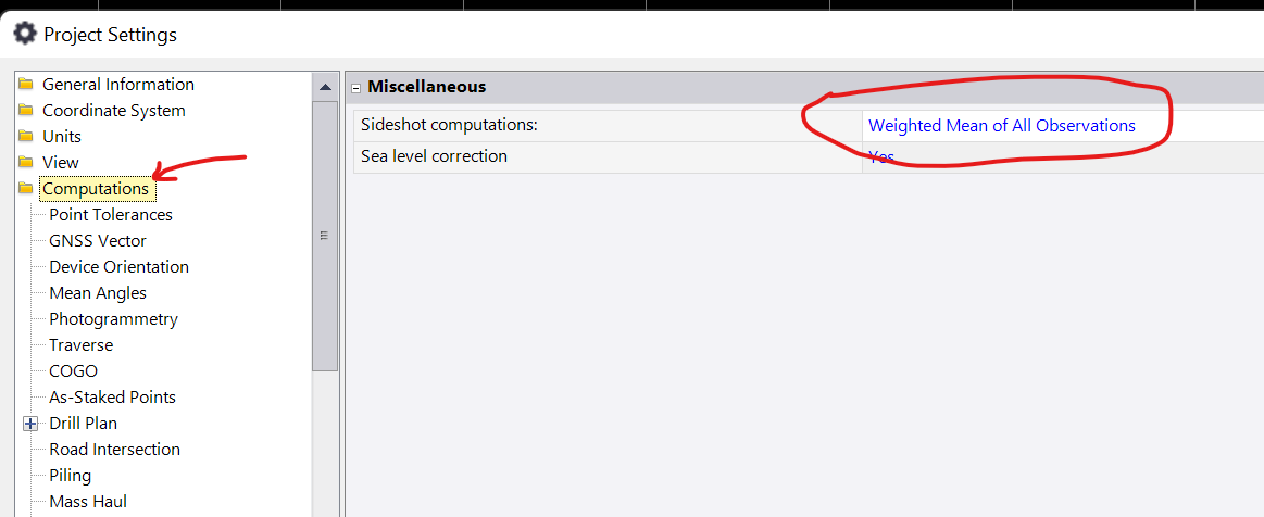
  1. If you go to Project Settings > Computations, what is your current setting for "Sideshot computations"?
  2. Have you considered running a Network Adjustment?
Dustin Sunderman's profile image
Dustin Sunderman
Hey Scott,

That bit of information helped a lot. TBC must have reset a default in there to single observation, and that is what was flagging up all my points. Ultimately, this is going to get adjusted out but I need to understand what my problem was. Now I can get into the other issues.

Thank you for the help!

Dustin