Trimble Business Center

 View Only
Expand all | Collapse all

Can I report a point elevation difference to alignment

  • 1.  Can I report a point elevation difference to alignment

    Posted 01-10-2019 20:08

    I would like to report a point in relation to an alignment, as is possible with the 'Station, Offset, Elevation Report', but would also like to include the alignment elevation and (optionally) the elevation difference between the point elevation and alignment at the same chainage.


    I would also like to do the same with surface elevations at interval along an alignment, again possible with the 'Station, Offset, Elevation Report' using surface cross sections with 0 left/right offsets.


    Is there a way to include alignment elevations the 'Station, Offset, Elevation Report', or is there another tool I have overlooked that will provide the desired result?


    - Rob


  • 2.  Re: Can I report a point elevation difference to alignment

    Posted 01-10-2019 21:18

    Funny - I had to do this the other day for something else I was doing. 


    Reporting the Elevation of the Alignment at intervals requires that you have a surface (can be a very small surface (created as a Corridor Surface). When you report it use the Surface Cross Section Option and enter Left 0 and Right 0 and pick the surface model and it will report just the 0 offset to give you the alignment. Make sure that your corridor surface is computed at the same interval that you are reporting, otherwise you will get some chording differences.


    The other things you are asking for, reporting Station, Offset, Elevation and Delta Elevation to the Center line elevation - not sure how I would do that, let me think on that one - that may take running 2 reports and merging the results in Excel. You may have to create a Corridor Surface with one element Left and right at a large offset and no delta elevation to the centerline, and then report the Station, Offset Elevation of the Point and then Station, Offset, Delta Elevation to the Surface in order to get what you need.


    I agree that this report could likely provide more options and allow you to select the values that you want to report, as it doesn't have all the options today. 


    You can use the Sideslope Command and enter an interval of e.g. 10m if that is the desired report Interval along the alignment, that will create you a linestring at the centerline (0 offset, 0 elevation delta) that has points at the 10m intervals. You can then use the Station Offset Report to report that string against the alignment and that should also give you what you want here.


    Sorry for the work arounds


    Alan


  • 3.  Re: Can I report a point elevation difference to alignment

    Posted 01-11-2019 11:43

    Rob

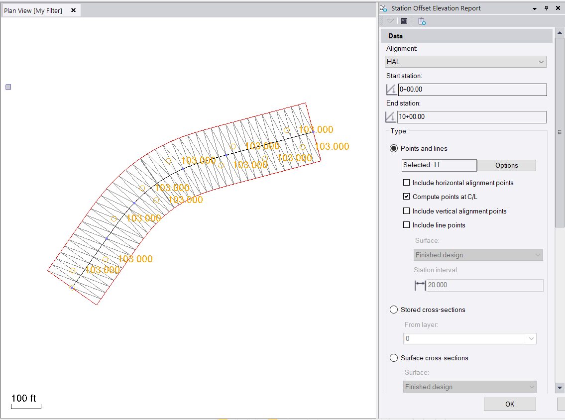
    With the following set up


    1. Created a HAL / VAL
    2. Created a bunch of points left and right of HAL/VAL
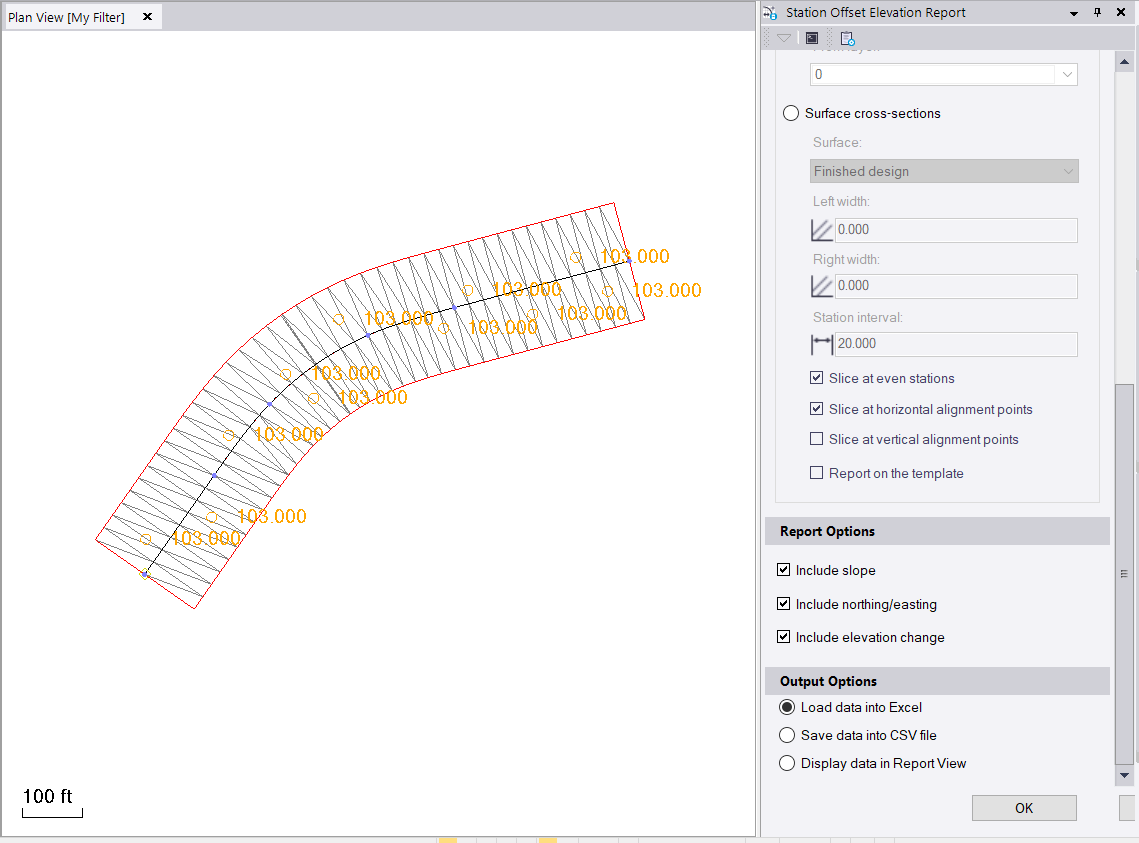
    3. Ran the Station Offset Elevation report using the following settings


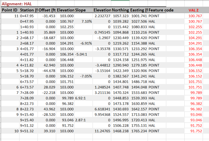
    1. I created this report - all the locations listed as Point are the Points. The VAL Z column in Red I computed using the Elevation Column - the Elevation Changed Column - You can see the VAL Z values for the Points Match the VAL Elevation on the subsequent lines tagged as HAL (computed at the alignment for each point) - these are easy to add into the report - you can then Filter on Code or Data Sort using Code to get the data grouped as you need before printing

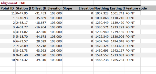
    Here I sorted based on Code (Z to A), Station (Smallest to Largest) (I had to remove the Station Format + first), and by Offset (Smallest to Largest) - this shows just the Points


    If you uncheck the Compute Points at CL then you don't get the Delta Elevations or the HAL Points


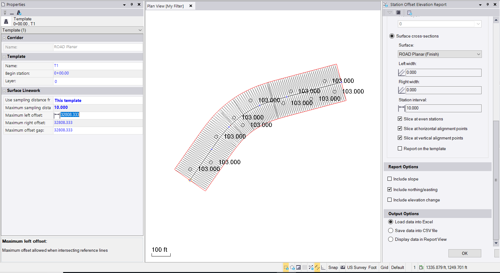
    For the Surface question, with the following settings (the surface shown is a shape left and right of CL that is at 100' offset and 0 elevation delta (i.e. planar to the VAL) - and I can use this to generate a Station, Offset, Elevation Report along the Alignment at e.g. 10' stations (Note, I changed the inteval setting for the corridor to match the interval I want to report to eliminate Chording errors - so in this case I am computing the Corridor at 10' Stations and Reporting 10' Stations - then the Z values should be correct for the VAL


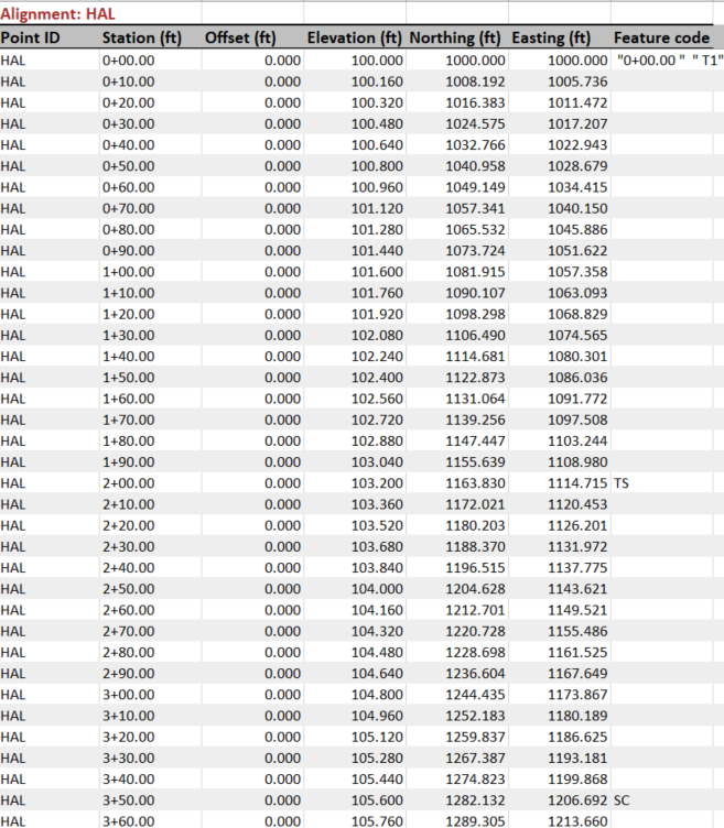
    and this is the output of the Report (i use this method to generate reports to use in Tilos for Profiles along surfaces)


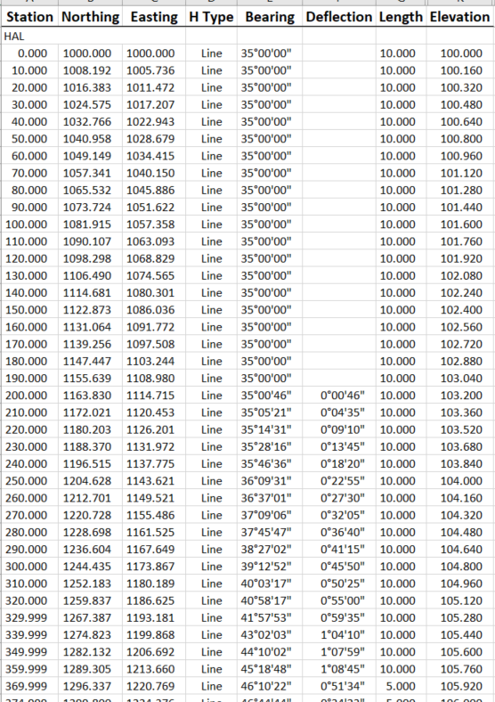
    If you explode the Corridor to create Linestrings and then run the Geometry Report (use F12 and type in Geometry you will find it), you can report the Centerline Linestring and you will get this output, note that this is not tied to the Alignment, so Stationing will wander off even 10s as you get further away from the Origin - you can always Round the Station Field and it will come back to the 10s unless your HAL is very long or has large numbers I guess (so not perfect).  You can however also report that linestring against the Alignment using the Station Offset Elevation report as well and then you will have real Stations.


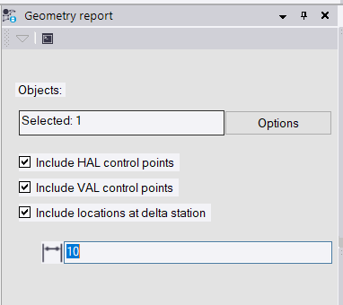
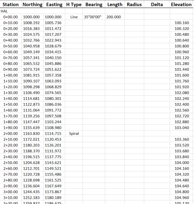
    You can also run a report on the HAL / VAL using Geometry Report using these settings and it will give you exactly what you wanted (Got there in the end) and without requiring a surface at all!


    Close to what you wanted?


    Alan


  • 4.  Re: Can I report a point elevation difference to alignment

    Posted 01-11-2019 12:05

    Thanks Alan. I’ll be able to generate what I need based on this. 


    - Rob