Trimble Business Center

 View Only

 GNSS static point survey with multiple base stations

ignace pelckmans's profile image
ignace pelckmans posted 08-19-2022 10:30
Hi,

I have three permanent base stations and made a two-hour survey of a single point in static mode with a R8s antenna. For that point I am interested in the vertical ellispoidal height, the accuracy on the horizontal is much less important. I understand I zould have to process the baselines and apply a network adjustment. However, I am a bit confused on which boxes I would have to thick in the network adjustment screen, or in other words, whether I should fix the 2D or h for my base stations:

If I only tick the h boxes, I get a height error of just 1.8 cm. Does that mean that the resulting vertical ellipsoidal height accruacy is indeed 1.8 cm?

Thank you for the help!

kind regards,
Ignace
Albert Olivier's profile image
Albert Olivier
Hi Ignace

Will it be possible to send me your vce file and the static data as well, need your data to help with this.

Regards
Scott Roberts's profile image
Scott Roberts
The check boxes there represent fixed values in your network adjustment. If you check 2D, you're telling TBC to constrain (i.e. set standard error = 0) that point's existing northing/easting (or lat/long) value. If you check the 'h' box, you're doing the same for the station's ellipsoidal height. Whether any given point should be held fixed or not is a survey judgement matter. It's really up to you to determine what is appropriate for your project and what you're observing, because there are so many variables involved in this that it's impossible to provide a direct answer to your question without being deeply involved in all aspects of the project.

I would recommend running the adjustment numerous times with different sets of parameters, examining the results, and picking the solution that you feel is the best. I would typically start with the closest reference station held fixed, and leave the others unchecked. That gives you 2 reference stations to use for checks. Since static is sensitive to base line length, the closest reference station would theoretically offer the lowest standard error, but this is highly dependent on the magnitude of your base line lengths (2 miles? 20 miles? 200 miles?) and the difference in length relative to the others.

Also, have you run a loop closure report? Do you have good results? If not, maybe you need to run an adjustment on your reference station network first, before trying to adjust the data derived from their positions. If you don't know the story behind those reference station coordinates, you can't really rely on them, so you may want to vet that information first and understand the relative error factors at play before you try to run your final adjustment and evaluate the quality of the results.
ian bissonnette's profile image
ian bissonnette
i would agree with scott but can add a couple comments. 
those check boxes are used to fix each coordinate, as he says in the horizontal and the vertical respectfully, but you can also expand the plus sign and assign a sigma 'float' value to them(i forget if it is 1 sigma or 2 sigma). in your case, if you happen to have any quality control information regarding the three base stations(we use a PPP service in canada which i think is similar to the OPUS service in the states), you could assign a value to let these stations move slightly since none of them are going to be an absolute known point. 
after you run the adjustment, you can look at the adjustment report to review how much the control coordinates have shifted. this report along with any quality control on the observed point that tbc provides would give an approximation of the quality of the observed point.
i would also mention that the quality of all these points will be dependant on the setups of all equipment, hopefully the permanent stations are in good calibration as they can get neglected. 

scott, i was under the impression that unlike rtk, static baselines do not degrade by increasing magnitude in the same way that rtk does, but we have also not run anything on a huge scale (200 mile) so have not had to deal with that problem. and i would not consider myself an expert.
Scott Roberts's profile image
Scott Roberts
@ian bissonnette I won't pretend to understand this on the level of Seeber, so for the sake of transparency I'm basing the statement regarding the correlation between standard errors and base line length on the datasheet for the instrument. In this case, the R8s was mentioned:

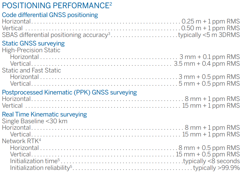
It is my understanding that the ppm component is derived from the length of the baseline and added to the fixed/nominal standard error. At short distances, the effect is negligible but at longer distances that 0.5ppm can become significant. I believe this is largely related to the lack of correlation of atmospheric conditions applicable to the two stations, but the amount of time that has passed since I learned this stuff leaves me questioning everything I think I know :)
ian bissonnette's profile image
ian bissonnette
scott. thanks. of course it makes sense to look at the spec of the gear. i guess the thing is that the numbers are pretty negligible for static. from my quick calc the ppm on 10km being 1mm in horizontal and 4mm in vertical. these seem pretty low but should be added to the consideration. but you are right on a 100km tie the ppm would up to 40mm in vertical which starts to be something.